
Weather Information

Weather Information
Objective: The student will be introduced to weather products and how they are used in day to day flight/ cross countries.
Completion Standards: The student will be able to read a METAR and TAF along with understanding different weather products and how they can be used.
References: foreflight,NOAA/ ADDS, WX-Brief
Equipment: White Board and markers, iPad/ computer
IP’s Actions:
Assess student
State the objective and completion standards
Writes down references
Provide attention getter
Present content
Assessment
Assign Homework
SP’s Actions:
Take notes
Ask Questions
Introduction:
(Attention Getter) : USE RAAMB slider to find some weather in USA
Motivation: will use this information in our day to day flights
Overview:
Use of real-time weather reports, forecasts, and charts for developing scenario-based training.
Product’s
ATIS/AWOS/ASOS
Airmets
Sigmets
Charts
Prog Charts
Content:
Use of real-time weather reports, forecasts, and charts for developing scenario-based training.
Importance of a thorough preflight weather briefing.
Where can it be obtained
Various means and sources of obtaining weather information:
ADDS
GFA Tool
ForeFlight
NOAA
WX-Brief
Product’s:
METAR (HOURLY)
Aviation routine weather report—observation of current surface weather reported in a standard international format
Type of report
Routine
is transmitted hourly
Special.
Given any time to update a METAR for rapidly changing weather, aircraft mishaps, etc.
Station identifier
four-letter code (e.g. KLAF). Alaska begins with PA, Hawaii begins with PH.
Date and time of report
reported in a six-digit group, first two digits are the date, last four are the time, in UTC.
Modifier — denotes that the METAR came from an automated source or was corrected.
AUTO — indicates the report came from an automated source.
A01 and A02 — indicate the type of precipitation sensors at the station.
COR — indicates a corrected report.
Wind — reported with five digits, unless the wind speed is more than 99 knots, in which case it becomes six digits.
First three digits indicate wind direction in tens of degrees. Last two digits indicate the speed of the wind in knots. Gusting shown with the peak gust after the “G”.
If wind varies more than 60 degrees and the speed more than 6 knots, a separate group of numbers, separated by a “V” will indicate the extremes of the directions.
Visibility — reported in statute miles.
RVR is sometimes reported following visibility—the distance a pilot can see down the runway in a moving aircraft. “R”, then runway number, a slant, and he visual range in feet.
Weather — includes weather phenomenon and qualifiers.
Phenomena describe precipitation, obscuration, etc. DZ, RA, HZ, SS, DS, SN, etc. Qualifiers show the intensity or proximity. -, +, VC, SH, TS, FZ, etc.
Sky condition - reported in the sequence of amount, height, and type. Height depicted with three digits, in hundreds of feet AGL. Clouds above 12,000 ft are not detected. Towering cumulus and cumulonimbus clouds are reported with their height.
The amount of sky coverage is reported in eighths of the sky from horizon to horizon.
SKC/CLR/FEW, FEW, SCT, BKN, OVC
Temperature and dewpoint—in degrees Celsius. Temperatures below 0°C preceded by the letter “M.”
Altimeter setting — preceded by the letter “A” and reported in inches of mercury in a four digit number. “PRESRR” or “PRESFR” represent rising or falling pressure.
Remarks — may include wind data, variable visibility, begin/end times of phenomenon, pressure info, and other necessary info.
TAF(Terminal aerodrome forecast)
Valid for a 24-hr period, and updated four times a day (0000Z, 0600Z, 1200Z, 1800Z).
Report established for the 5SM radius around an airport
Type of report—can be a routine forecast (RAF) or an amended forecast (TAF AMD).
ICAO station identifiers—same as METAR.
Date and time of origin—six number code, same as METAR.
Valid period date and time—given by a 6-digit group: the first two are the date, the next two are the beginning time for the valid period; the last two are the end time.
Forecast wind—the wind direction and speed forecast, given in a 5- digit group.
Forecast visibility—given in statute miles; if greater than 6SM shown as P6SM.
Forecast change group—includes the expected conditions and time period for any significant weather change forecast to occur.
FM — from used when a rapid and significant change is expected within an hour
BECMG — becoming used when a gradual change is expected over no more than two hours
TEMPO — temporary used for temporary fluctuations, expected to last less than an hour.
Probability forecast—percentage describing the probability of thunderstorms and precipitation occurring in the coming hours.
Pireps (Pilot Reports)
UA vs UAA
Routine
Urgent
ADDS
Foreflight
ATIS/AWOS/ASOS
ASOS- Automated Surface Observing System
Continuous minute by minute observations that are used to generate a METAR and provide information. Transmits SPECI report whenever it detects a significant change in conditions.
AWOS- Automated Weather Observing System
First widely installed automated weather data gathering system at airports. Available in lesser configurations.
Basic Observtion systems
Altimeter
Wind direction/ speed
Visibility
Clouds
ATIS- Automated Terminal Information Service
Continuous broadcast of recorded non-control information in busier terminal areas. Contains essential information such as weather and active runways and approaches. It is given a letter designation and is updated when there is a significant change.
Re-recorded at every update. Data may be entered by hand, from a METAR, or directly from the sensors. Modern systems are fully automated.
Airmets (Issued every 6 hours starting at 0245 UTC)
Types
Tango (turbulence)
Zulu (Icing)
Sierra (IFR)
Sigmets
Non-Convective (issued every 4 hours or 6 in hurricanes)
Severe Icing
Severe or extreme Turbulence
Dust storms/ Visibility less that 3 SM
Volcanic Ash
Convective (Valid for 2 hours)
Thunderstorms
Severe or greater turbulence
Sever icing, low level wind shear
Charts
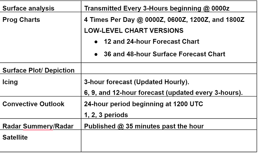
*Notes*
High and low Pressure systems
Troughs and ridges
Fronts
**Dupage weather** <<LINK
Surface analysis (NOAA storm prediction center)

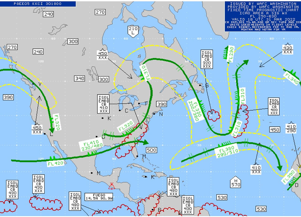
Prog charts
High level (Issued 4 times a day, valid time 00Z, 06Z, 12Z, 18Z.)
Low Level (12 hours and 24 hours)

Surface Plot (Explain FRONTS)

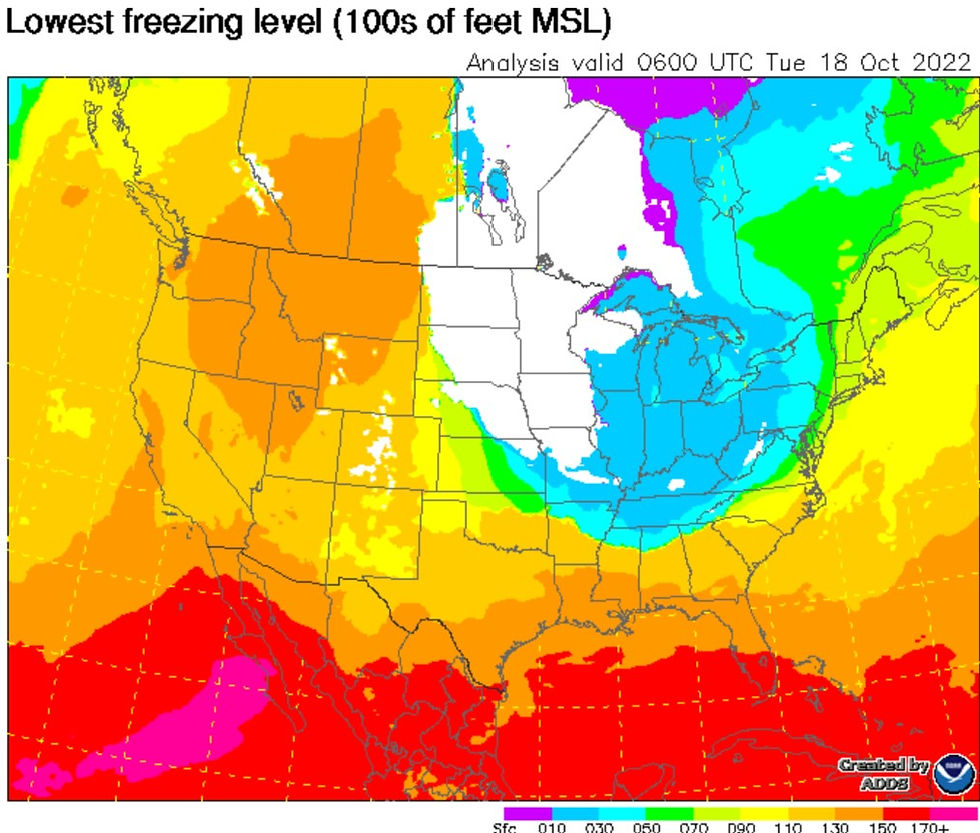
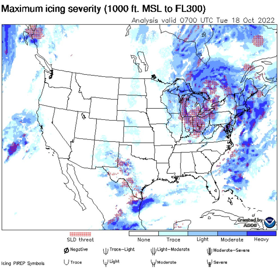
Icing Charts
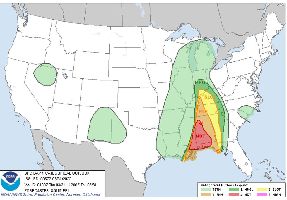
Convective outlook
Radar/ Radar Summary chart
Forflight
ADDS

Satellite
Forflight
Raamb Slider
Dupage
Conclusion
Use of real-time weather reports, forecasts, and charts for developing scenario-based training.
Product’s
ATIS/AWOS/ASOS
Airmets
Sigmets
Charts
Prog Charts
(Questions to assess student)
What does the metar for KDAB say?
What is the TAF?
What are some charts we can look at?
What is wind shear?
Why is it important to check the weather before a flight?
HW:
Look at the weather next time (For Flight)